The Palestine Papers have set the news agenda for today with details emerging of how Palestinian negotiators agreed to Israel annexing all but one of the settlements built illegally in occupied East Jerusalem.
Al Jazeera and the Guardian have shared access to thousands of documents in the biggest ever leak over the Middle East peace talks. You can see an interactive guide to them here.
As reported today, the Israeli negotiator Tzipi Livni is recorded as dismissing the offer out of hand because the Palestinians had refused to concede Har Homa, as well as the settlements at Ma’ale Adumim, near Jerusalem, and Ariel, deeper in the West Bank. Israel’s position was fully supported by the Bush administration.
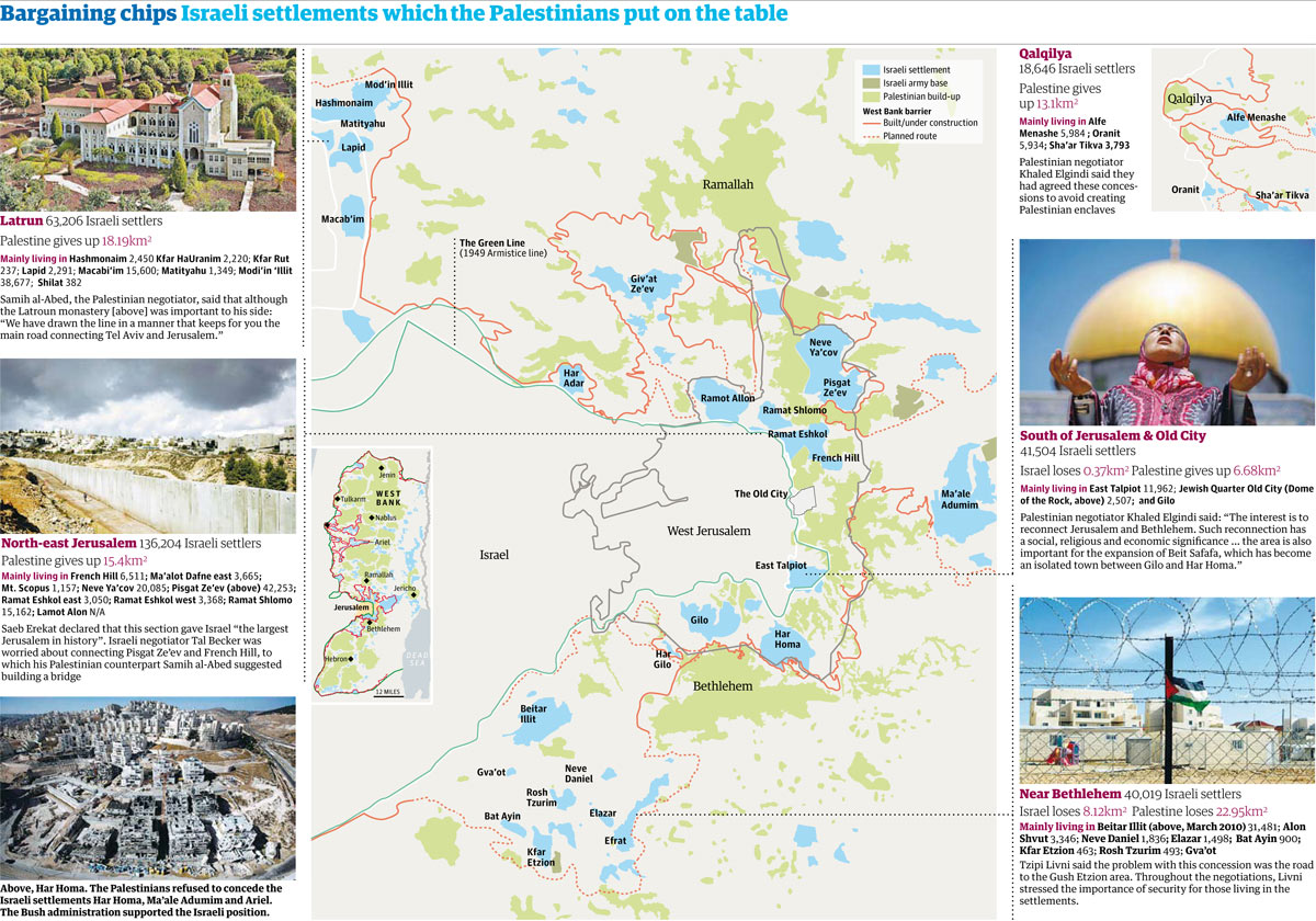
We’ve extracted the key data for you from this document – which outlines the places Palestinian negotiators were willing to negotiate over. Our map (shown above) is based on a background image from B’Tselem, which produces incredibly detailed maps of the area – the same map seems to have been used in the leaked document.
A Google Fusion tables map of the areas shows how they are in the most hotly-contested part of the region – although Fusion tables does not appear to have any roads or town names for Israel. There’s a much more useful version produced by Al Jazeera here.
The key data appears to be that:
• Israel and Palestine would swap 119 square KM
• 56,000 settlers (12%) would be evacuated, leaving 413,000 (88%) in situ
The full data is below. What can you do with it?
Data summary
Palestine areas negotiated
Click heading to sort table. Download this data
Area 1, Bethlehem
Area 1, Bethlehem, TOTAL
40,019
Bitar Illit
Area 1, Bethlehem
31,481
Alon Shvut
Area 1, Bethlehem
3,346
Neve Daniel
Area 1, Bethlehem
1,836
Elazar
Area 1, Bethlehem
1,498
Bat Ayin
Area 1, Bethlehem
900
Kfar Etzion
Area 1, Bethlehem
463
Rosh Tzurim
Area 1, Bethlehem
493
Gva’ot
Area 1, Bethlehem
Area 2, South of Jerusalem
Area 2, South of Jerusalem, TOTAL
41,504
East Tel Piot
Area 2, South of Jerusalem
11,962
Jewish Quarter (Old City)
Area 2, South of Jerusalem
2,507
Gilo
Area 2, South of Jerusalem
Area 3, North Jerusalem
Area 3, North Jerusalem, TOTAL
136,204
French Hill
Area 3, North Jerusalem
6,511
Ma’alot Dafne (east)
Area 3, North Jerusalem
3,665
Mt. Scopus
Area 3, North Jerusalem
1,157
Neve Ya’cov
Area 3, North Jerusalem
20,085
Pisgat Ze’ev
Area 3, North Jerusalem
42,253
Ramat Eshkol (east)
Area 3, North Jerusalem
3,050
Ramal Eshkol (west)
Area 3, North Jerusalem
3,368
Ramat Shlomo
Area 3, North Jerusalem
15,162
Ramot Alon
Area 3, North Jerusalem
Area 4
Area 4 TOTAL
2,673
Area 5, Latroun
Area 5, Latroun, TOTAL
63,206
Hashmonaim
Area 5, Latroun
2,450
Kfar HaUranim
Area 5, Latroun
2,220
Kfar Rut
Area 5, Latroun
237
Lapid
Area 5, Latroun
2,291
Macabi’im
Area 5, Latroun
15,600
Matityahu
Area 5, Latroun
1,349
Modi’in ‘Illit
Area 5, Latroun
38,677
Shilat
Area 5, Latroun
382
Area 6, Qalqilya
Area 6, Qalqilya, TOTAL
18,646
Alfi Minasheh
Area 6, Qalqilya
5,984
Uranit
Area 6, Qalqilya
5,934
Shi’ar Tikva
Area 6, Qalqilya
3,793
Download the data
• DATA: download the full spreadsheet
More data
Data journalism and data visualisations from the Guardian
World government data
• Search the world’s government data with our gateway
Development and aid data
• Search the world’s global development data with our gateway
Can you do something with this data?
• Flickr Please post your visualisations and mash-ups on our Flickr group
• Contact us at data@guardian.co.uk
• Get the A-Z of data
• More at the Datastore directory
• Follow us on Twitter
• Like us on Facebook